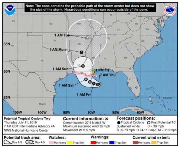
7 A.M. STORM UPDATE: SYSTEM BENDS TOWARD ST. MARY
BULLETIN
Potential Tropical Cyclone Two Intermediate Advisory Number 4A
NWS National Hurricane Center Miami FL AL022019
700 AM CDT Thu Jul 11 2019
...DISTURBANCE EXPECTED TO BECOME A DEPRESSION LATER TODAY...
...STORM SURGE, HEAVY RAINS, AND HURRICANE CONDITIONS ARE
POSSIBLE ACROSS THE NORTH-CENTRAL GULF COAST IN A COUPLE OF DAYS...
SUMMARY OF 700 AM CDT...1200 UTC...INFORMATION
----------------------------------------------
LOCATION...27.6N 88.5W
ABOUT 115 MI...185 KM SSE OF THE MOUTH OF THE MISSISSIPPI RIVER
ABOUT 225 MI...360 KM SE OF MORGAN CITY LOUISIANA
MAXIMUM SUSTAINED WINDS...35 MPH...55 KM/H
PRESENT MOVEMENT...W OR 270 DEGREES AT 5 MPH...7 KM/H
MINIMUM CENTRAL PRESSURE...1005 MB...29.68 INCHES
WATCHES AND WARNINGS
--------------------
CHANGES WITH THIS ADVISORY...
None.
SUMMARY OF WATCHES AND WARNINGS IN EFFECT...
A Storm Surge Watch is in effect for...
* Mouth of the Pearl River to Intracoastal City
A Hurricane Watch is in effect for...
* Mouth of the Mississippi River to Cameron
A Tropical Storm Watch is in effect for...
* Mouth of the Mississippi River northward to the Mouth of the Pearl
River
A Storm Surge Watch means there is a possibility of life-
threatening inundation from rising water moving inland from the
coastline in the indicated locations during the next 48 hours.
For a depiction of areas at risk please see the National Weather
Service Storm Surge Watch/Warning Graphic available at
hurricanes.gov.
A Hurricane Watch means that hurricane conditions are possible
within the watch area. A watch is typically issued 48 hours
before the anticipated first occurrence of tropical-storm-force
winds conditions that make outside preparations difficult or
dangerous.
A Tropical Storm Watch means that tropical storm conditions are
possible within the watch area generally within 48 hours.
Warnings and additional watches may be required for portions of the
northern Gulf coast later today. Interests elsewhere along the U.S.
Gulf Coast from the Upper Texas Coast to the Florida Panhandle
should monitor the progress of this system.
For storm information specific to your area, including possible
inland watches and warnings, please monitor products issued by your
local National Weather Service forecast office.
DISCUSSION AND OUTLOOK
----------------------
At 700 AM CDT (1200 UTC), the disturbance was centered near latitude
27.6 North, longitude 88.5 West. The system is moving toward the
west near 5 mph (7 km/h), but a west-northwest motion is expected on
Friday followed by a northwestward track by early Saturday. On the
forecast track, the system is expected to approach the Louisiana
coast this weekend.
Reports from a NOAA Hurricane Hunter aircraft indicate that maximum
sustained winds are near 35 mph (55 km/h) with higher gusts.
Strengthening is forecast during the next couple of days, and
the disturbance is forecast to become a tropical depression or a
tropical storm later today, and could become a hurricane by late
Friday.
The associated thunderstorm activity is gradually becoming
better organized, and the disturbance is expected to become a
tropical depression or a tropical storm later today or Friday.
* Formation chance through 48 hours...high...near 100 percent
* Formation chance through 5 days ...high...near 100 percent
The minimum central pressure based on recent Air Force Reserve
Hurricane Hunter data is 1005 mb (29.68 inches).
HAZARDS AFFECTING LAND
----------------------
Key Messages for this system can be found in the Tropical Cyclone
Discussion under AWIPS header MIATCDAT2 and WMO header WTNT32 KNHC.
STORM SURGE: The combination of a dangerous storm surge and the
tide will cause normally dry areas near the coast to be flooded by
rising waters moving inland from the shoreline. The water could
reach the following heights above ground somewhere in the indicated
areas if the peak surge occurs at the time of high tide...
Mouth of the Pearl River to Intracoastal City...3 to 6 ft
Surge-related flooding depends on the relative timing of the surge
and the tidal cycle, and can vary greatly over short distances. For
information specific to your area, please see products issued by
your local National Weather Service forecast office.
RAINFALL: The system is expected to produce total additional rain
accumulations of 10 to 15 inches near and inland of the central Gulf
Coast through early next week, with isolated maximum rainfall
amounts of 20 inches.
Rainfall amounts exceeding 6 to 9 inches have already occurred
across portions of the New Orleans metropolitan area, which
has resulted in flooding.
WIND: Hurricane conditions are possible within the Hurricane Watch
area by Friday night, with tropical storm conditions possible by
early Friday.
TORNADOES: A tornado or two are possible tonight and Friday
across southern portions of Louisiana and Mississippi.