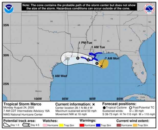
MARCO WEAKENS TO TROPICAL STORM
BULLETIN
Tropical Storm Marco Intermediate Advisory Number 16A
NWS National Hurricane Center Miami FL AL142020
700 AM CDT Mon Aug 24 2020
...MARCO PRODUCING HEAVY RAINFALL AND GUSTY WINDS ALONG PORTIONS OF
THE NORTHERN GULF COAST...
SUMMARY OF 700 AM CDT...1200 UTC...INFORMATION
----------------------------------------------
LOCATION...28.1N 88.4W
ABOUT 85 MI...135 KM SSE OF THE MOUTH OF THE MISSISSIPPI RIVER
MAXIMUM SUSTAINED WINDS...50 MPH...80 KM/H
PRESENT MOVEMENT...NW OR 325 DEGREES AT 10 MPH...17 KM/H
MINIMUM CENTRAL PRESSURE...1005 MB...29.68 INCHES
WATCHES AND WARNINGS
--------------------
CHANGES WITH THIS ADVISORY:
None.
SUMMARY OF WATCHES AND WARNINGS IN EFFECT:
A Storm Surge Warning is in effect for....
* Morgan City Louisiana to Ocean Springs Mississippi
* Lake Borgne
A Tropical Storm Warning is in effect for...
* Intracoastal City to the Mississippi/Alabama border
* Lake Pontchartrain, Lake Maurepas, and Metropolitan New Orleans
A Storm Surge Warning means there is a danger of life-threatening
inundation, from rising water moving inland from the coastline,
during the next 36 hours in the indicated locations. For a
depiction of areas at risk, please see the National Weather
Service Storm Surge Watch/Warning Graphic, available at
hurricanes.gov. This is a life-threatening situation. Persons
located within these areas should take all necessary actions to
protect life and property from rising water and the potential for
other dangerous conditions. Promptly follow evacuation and other
instructions from local officials.
A Tropical Storm Warning means that tropical storm conditions are
expected somewhere within the warning area, in this case within 12
to 24 hours.
For storm information specific to your area, including possible
inland watches and warnings, please monitor products issued by your
local National Weather Service forecast office.
DISCUSSION AND OUTLOOK
----------------------
At 700 AM CDT (1200 UTC), the center of Tropical Storm Marco was
located near latitude 28.1 North, longitude 88.4 West. Marco is
moving toward the northwest near 10 mph (17 km/h). Marco is
forecast to approach the coast of Louisiana this afternoon, and then
turn westward and move very close to the coast of Louisiana through
Tuesday night.
Data from an Air Force Reserve Hurricane Hunter aircraft indicate
that maximum sustained winds have decreased to near 50 mph (80 km/h)
with higher gusts. Further weakening is expected, and Marco is
forecast to become a tropical depression late on Tuesday and
dissipate on Wednesday.
Tropical-storm-force winds extend outward up to 105 miles (165 km),
primarily northeast of the center.
The estimated minimum central pressure is 1005 mb (29.68 inches).
HAZARDS AFFECTING LAND
----------------------
STORM SURGE: The combination of a dangerous storm surge and the
tide will cause normally dry areas near the coast to be flooded by
rising waters moving inland from the shoreline. The water could
reach the following heights above ground somewhere in the indicated
areas if the peak surge occurs at the time of high tide...
Morgan City LA to Ocean Springs MS, including Lake Borgne...2-4 ft
The deepest water will occur along the immediate coast in areas of
onshore winds, where the surge will be accompanied by large and
dangerous waves. Surge-related flooding depends on the relative
timing of the surge and the tidal cycle, and can vary greatly over
short distances. For information specific to your area, please see
products issued by your local National Weather Service forecast
office.
WIND: Tropical storm conditions are expected to start by this
afternoon in portions of the warning area.
RAINFALL: Marco is expected to produce total rainfall accumulations
of 3 to 5 inches with isolated maximum amounts of 10 inches across
portions of the northeast and north-central Gulf coast through
Tuesday. This rainfall may result in areas of flash, urban and
small stream flooding in the area.
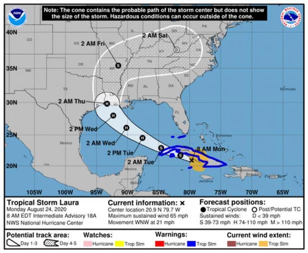
TROPICAL STORM LAURA
BULLETIN
Tropical Storm Laura Intermediate Advisory Number 18A
NWS National Hurricane Center Miami FL AL132020
800 AM EDT Mon Aug 24 2020
...NOAA AND AIR FORCE RECONNAISSANCE AIRCRAFT FIND LAURA MOVING
WEST-NORTHWESTWARD JUST SOUTH OF THE COAST OF CENTRAL CUBA....
SUMMARY OF 800 AM EDT...1200 UTC...INFORMATION
----------------------------------------------
LOCATION...20.9N 79.7W
ABOUT 125 MI...200 KM ESE OF CAYO LARGO
ABOUT 205 MI...330 KM ESE OF THE ISLE OF YOUTH
MAXIMUM SUSTAINED WINDS...65 MPH...100 KM/H
PRESENT MOVEMENT...WNW OR 290 DEGREES AT 21 MPH...33 KM/H
MINIMUM CENTRAL PRESSURE...1000 MB...29.53 INCHES
WATCHES AND WARNINGS
--------------------
CHANGES WITH THIS ADVISORY:
None
SUMMARY OF WATCHES AND WARNINGS IN EFFECT:
A Tropical Storm Warning is in effect for...
* Little Cayman and Cayman Brac
* Cuban provinces of Camaguey, Las Tunas, Holguin, Guantanamo,
Santiago de Cuba, Granma, Ciego De Avila, Sancti Spiritus, Villa
Clara, Cienfuegos, Matanzas, Mayabeque, La Habana, Artemisa, Pinar
del Rio, and the Isle of Youth
* Florida Keys from Craig Key to Key West
* Dry Tortugas
The Tropical Storm Warning means that tropical storm conditions are
expected somewhere within the warning area, in this case within the
next 12 to 24 hours.
Hurricane and Storm Surge Watches will likely be required for
portions of the U.S. northwest Gulf coast area by this evening.
For storm information specific to your area in the United States,
including possible inland watches and warnings, please monitor
products issued by your local National Weather Service forecast
office. For storm information specific to your area outside of the
United States, please monitor products issued by your national
meteorological service.
DISCUSSION AND OUTLOOK
----------------------
At 800 AM EDT (1200 UTC), the center of Tropical Storm Laura was
located near latitude 20.9 North, longitude 79.7 West. Laura is
moving toward the west-northwest near 21 mph (33 km/h), and this
general motion with some decrease in forward speed is expected over
the next couple of days. A turn toward the northwest is forecast by
Wednesday. On the forecast track, the center of Laura will move
over the Caribbean Sea just offshore the southern coast of Cuba
today, and move into the southeastern Gulf of Mexico by early
Tuesday morning. Laura is then forecast to move over the central and
northwestern Gulf of Mexico Tuesday night and Wednesday.
Maximum sustained winds are near 65 mph (100 km/h) with higher
gusts. Gradual strengthening is expected, and Laura is forecast to
become a hurricane by early Tuesday.
Tropical-storm-force winds extend outward up to 175 miles (280 km)
from the center.
The estimated minimum central pressure is 1000 mb (29.53 inches).
HAZARDS AFFECTING LAND
----------------------
RAINFALL: Laura is expected to produce the following storm total
rainfall accumulations through Tuesday:
Jamaica and Cuba: 4 to 8 inches, with maximum amounts of 12 inches.
Cayman Islands: 2 to 4 inches, maximum amounts of 6 inches.
Florida Keys, Turks and Caicos Islands, and the Northwest Bahamas:
1 to 2 inches.
Across the Greater Antilles this heavy rainfall could lead to
life-threatening flash and urban flooding, and the potential for
mudslides.
From late Wednesday into Friday, Laura is expected to produce
rainfall of 5 to 10 inches, with isolated maximum amounts of 15
inches across portions of the west-central U.S. Gulf Coast near the
Texas and Louisiana border north into portions of the lower
Mississippi Valley. This rainfall could cause widespread flash and
urban flooding, small streams to overflow their banks, and the
possibility of some minor river flooding across this region.
WIND: Tropical storm conditions are expected to spread westward
within the warning area in Cuba through today. Tropical storm
conditions are expected in Little Cayman and Cayman Brac today.
Tropical storm conditions are also expected within the warning area
in the middle and lower Florida Keys and the Dry Tortugas this
afternoon and tonight.
SURF: Swells generated by Laura are affecting portions of
Hispaniola, eastern Cuba, the southeastern Bahamas and the
Turks and Caicos Islands. These swells are expected to spread
across central and western Cuba, the central and northwestern
Bahamas, and the Florida Keys today. Please consult products
from your local weather office.
TORNADOES: An isolated tornado will be possible later today into
tonight across the Florida Keys.
NEXT ADVISORY
-------------
Next complete advisory at 1100 AM EDT.
SURF: Swells generated by Marco are likely to affect portions of
the northern Gulf Coast for the next couple of days. These swells
are likely to cause life-threatening surf and rip current
conditions. Please consult products from your local weather office.
TORNADOES: A couple of tornadoes will be possible today from
southeast Louisiana to the western Florida Panhandle.